| Student: | J. Grift |
|---|---|
| Timeline: | February 2022 - 15 February 2026 |
According to global estimates, 70-75 percent of the people in the world do not have access to a legal land administration system that records and protects their land rights. Next to social, political, and economic causes, technological causes can play a significant role in the lack of such a formal system. In the last few decades, conventional ground-based survey methods have helped high-income countries build up countrywide cadastral maps with high accuracy. However, this approach is too labor-intensive and expensive for most mid and low-income countries and could take decades to complete. The Fit-For-Purpose Land Administration (FFPLA) tries to solve this problem. Two principles of the FFPLA approach are (i) the focus on general visible cadastral boundaries and (ii) the acquisition of these cadastral boundaries using satellite images and aerial photography. These two principles have increased demand for automated cadastral boundary delineation. Recent studies on cadastral boundary delineation using deep learning and remote sensing data show promising results. However, the number of studies is limited. Recent studies were focused on small study areas, did not implement the newest deep learning models, and did not investigate the generalization capability of the deep learning models in other geographical locations on a large scale.
This Ph.D. project will investigate the application of state-of-the-art deep learning models in combination with remotely sensed imagery for cadastral mapping purposes. The main objectives of this research are (figure):
- To review automatic boundary extraction methods based on deep learning and remotely sensed imagery for cadastral mapping purposes.
- To develop a deep learning method to automatically extract visible cadastral boundaries using remotely sensed imagery.
- To transfer knowledge from reference data-rich areas to reference data-scarce areas.
- To create a semi-automated deep learning-based delineation method with a human in the loop.
- To create a GIS toolbox that implements the investigated deep learning methods and can be used to create final cadastral maps
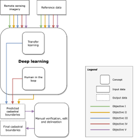
Figure - Conceptual framework and relations with research objectives
Meet the team