| Student: | |
|---|---|
| Timeline: | January 2018 - 8 January 2022 |
| Sources of funding: | University of Botswana (UB) |
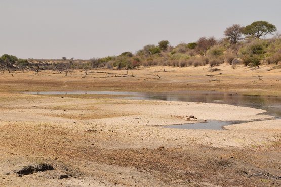
The Boteti River returning
SOURCE: http://www.elephantsforafrica.org/the-return-of-the-boteti-by-hayley-blackwell-12-oct-2016
Groundwater is a very important resource in the semi-arid Botswana, as it supplies around 60% of the country national water demand while supplying all the demand in the Boteti River Hydrological System (BRHS) study area. Due to the ever-increasing water demand and climate change, the resources are faced with a lot of uncertainty regarding their sustainability. The Boteti River, an outflow of the Okavango Delta, serves as a significant source of recharge to the aquifer’s groundwater resources in the BRHS. The river has a peculiar tendency of wet and dry spells, which affect groundwater recharge. An investigation of the hydrological processes in the BRHS, in both, spatial and temporal dimensions, is therefore highly desirable by Botswana Government. Besides, no such study to assess the spatio-temporal variability of river-groundwater interaction has been conducted yet, to explain the reason(s) why after more than 20 years of no-flow, recently, the Boteti River started to flow and to investigate the impact of climate change on the river-groundwater interactions and on groundwater resources. The overall objective of this study is to assess the spatiotemporal variability of surface-groundwater interaction in the BRHS. This will be achieved by the attainment of the following; a) spatiotemporal assessment of potential recharge in the BRHS - by application of coupled remote sensing and ground-based data b) hydrological assessment of the Boteti River channel flow over time by the use of USGS-PRMS code; c) assessment of surface-groundwater interaction in the BRHS – by the use of the USGS-GSFLOW code; and d) investigation of the impact of climate change on groundwater resources of the BRHS forward by forcing climatic scenarios of the Global Climate Model CMIP5 on the calibrated GSFLOW model and backwards by using the fragmented historical data for the study area.
Meet the team