| Student: | M. Owusu MSc |
|---|---|
| Timeline: | November 2023 - 6 November 2027 |
Cities in many Low- and Middle-Income countries (LMICs) continue to face rapid urbanization, localized impact of climate change, and unsustainable economic development. Globally, the most rapid growth in urban vulnerability and deprivation has been in cities, especially slums, unplanned and informal settlements, and small and medium-sized urban centers (Intergovernmental Panel on Climate Change (IPCC), 2023). Over 1.1 billion people lived in slums or slum-like living conditions in 2020, and in Sub-Saharan Africa, more than half of urban residents live in deprived living conditions (UN-Habitat, 2022; United Nations, 2020). The number of people being added to African and Asian cities today is unprecedented in human history; for example, Lagos (Nigeria) and Kinshasa (D.R. Congo) are adding 623,000 and 757,000 people per year, respectively (United Nations, 2019). The rapid population growth is not matched with infrastructure provision such as housing and public services (UN-Habitat, 2022).
Government and policymakers need high-resolution maps and granular statistics about the urban poor (Thomson, Kuffer, et al., 2020). This information is essential to designing programs and building infrastructure and social services at such a pace that the most vulnerable segment of the urban population is not left behind (Smythe & Blumenstock, 2022). The most vulnerable segment includes those living in deprived living conditions and slums such as substandard living conditions, prone to disaster, and lack of sanitation, and infrastructure. Unfortunately, most cities in LMICs do not have reliable, timely, and/or high-resolution spatial data on urban deprivation. Urban deprivation or deprived area is defined as an area with high social, environmental, and economic risks and substandard living conditions that are prone to disaster (Abascal et al., 2022). They are often characterized by high building density, irregular road patterns, small building structures and often in areas with unsafe living conditions such as close to river banks, and close to railway (Mahabir et al., 2018a).
The emergence of digital technologies, particularly Earth Observation (EO) and Artificial Intelligence (AI), offer new ways to obtain comprehensive data on urban deprivation. They allow for large-area mapping and spatiotemporal analysis at a lower cost compared to traditional methods. However, what is often lacking to ensure the trustworthiness and user-friendliness of EO products is the alignment with local data needs and requirements, effective communication strategies, low cost solution and scalable and transferable methods (Gevaert, 2022; Kuffer et al., 2018, 2021; Stark et al., 2024). The major challenges faced by deprived area mapping in the EO community are (i) inadequate understanding of local context knowledge, (ii) limited information on end-user requirements (Kuffer et al., 2021), (iii) limited information on slum ML-based geoethics to making information publicly available (Durk, 2017), (iv) no agreed upon scalable citywide and transferable mapping methods (Kuffer et al., 2020; Stark et al., 2020) and (v) limited understanding of uncertainties and communication strategies (Fisher et al., 2022). This PhD thesis aims to develop scalable and transferable methods for deprived area mapping that integrate the social, spatial, and technical aspects.
Motivated by the need to produce policy-driven geoinformation, this study shifts from traditional data-driven (Leonita et al., 2018) to user-driven approaches (Kuffer et al., 2021). We adopted a socio-geo-technical approach as shown in figure 1. This approach allowed us to combine social, spatial, and technical methodological framing to design methods that integrate ML-based modeling with the end-user requirements, geoethical consideration, uncertainties, and communication. This approach allows the inclusion of both technical and non-technical aspects. First, the study contextualizes and conceptualizes deprived area mapping by aligning EO methods with societal needs and concerns, including ethics and end-user requirements. Second, we explore low-cost solutions using low/freely available geoinformation data and open-source tools to map deprived areas in large areas across multiple cities. This will help develop and test scalable and transferable methods and allow the reproducibility of work. Lastly, we will quantify spatial explicit uncertainties and assess how different users associate with uncertainties. This will help to increase end-users’ confidence in using such models.
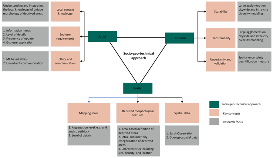
Figure 1. Overview of socio-geo-technical approach
Meet the team