At the University of Twente’s Faculty of Geo-Information Science and Earth Observation, our aim is to build capacity and strengthen the institutional development of both professional and academic organizations as well as individuals. We take an application-oriented approach, directed at finding solutions for and strengthening civil society in addressing issues of global, national, and local dimensions. This article, an abridged version of a previously published article on med-geo.de, describes our typical multidisciplinary approach in one of our valued educational courses, from the perspective of our students.
Global challenges, local action
Global 21st-century challenges, as caused by or related to climate change, rapid urbanization, and increased resource use, and their solutions, call for careful regional and local level consideration via active engagement across scientific disciplines. Through ITC’s Global Challenges – Local Action course, student awareness is raised to these issues. Building on the educational specialization tracks of the Master Geo-information Science and Earth Observation (M-Geo), not only do students learn about internationally recognized key global challenges, such as climate change, food security, rapid urbanization, natural and man-made hazards, energy transition, freshwater availability, degradation of fragile ecosystems and global health, but they also apply their geo-spatial and disciplinary knowledge and skills. In teams, student groups analyze a global issue more in-depth and collaboratively design a response (plan, strategy, or policy recommendation) at the local level. For this project part, groups can choose from different themes, one of which is GeoHealth.
GeoHealth project
In spring 2021, five student groups at ITC addressed and solved a spatial analysis problem on global health, creatively using geoinformation technology to support informed decision-making at the local level. Healthy populations are seen as critical to sustainable development, with numerous factors determining health including population characteristics, socioeconomic conditions, the environment, exposure to health risks and access to healthcare and governance. In spite of the progress made in global health over the past decades, many challenges remain. In response, academics, government agencies, and public health institutions – and our students - increasingly use spatial data and geoinformation technology to analyze access to health services, identify, understand, and predict geographic variations in health status and disease occurrence, monitor and map health trends with the aim to develop more effective health care interventions. Linking the analysis with a global policy framework (e.g. United Nations Agenda for Sustainable Development) was central, as were reflections on the potential role of geoinformation and earth observation. The groups had several case studies to build their projects on with support from Sherif Amer, Johannes Flacke (Department of Urban and Regional Planning and Geo-Information Management), Paulo Raposo (Department of Geo-Information Processing), Frank Osei, and Carmen Anthonj (Department of Earth Observation Science).
Analyzing the underlying environmental and socio-economic factors affecting Malaria in Rwanda
A Rwanda-based case study was related to diseases that frequently occur in the Global South. The main goal was to investigate potential linkages between socioeconomic and environmental factors and the occurrence of disease.
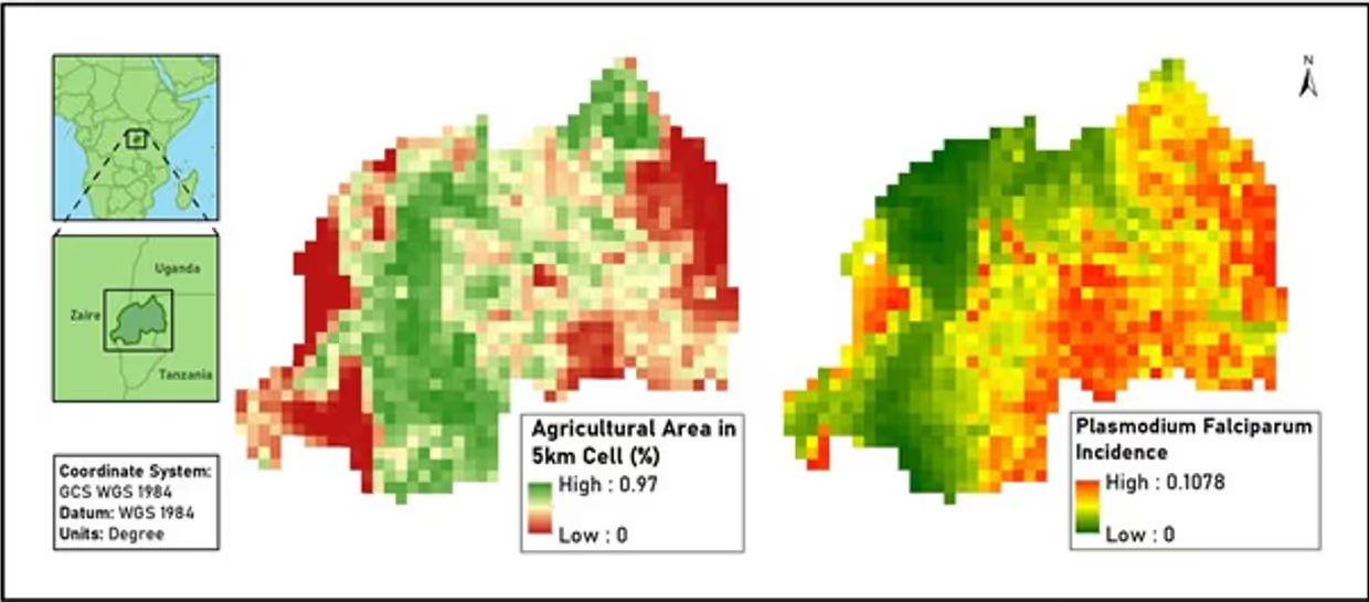
In Rwanda, Malaria poses a major health threat, despite various control measures undertaken. In line with the United Nations Sustainable Development Goal 3 to ensure healthy lives and promote well-being for all at all ages, and Target 3.3 to end the epidemics of AIDS, tuberculosis, malaria and neglected tropical diseases and combat hepatitis, water-borne diseases, and other communicable diseases by 2030, our students Biman Biswas, Florencio Campomanes V, Diana Fernanda Collazos Cortes, İkra Durmuş, Brian Mulenga Mutasha, and Meenal Sharma aimed to understand the underlying factors affecting malaria occurrence in Rwanda. They considered different environmental and socio-economic factors, including temperature, precipitation, land cover, elevation, and travel time to healthcare facilities in their multi-linear regression and generalized linear model. Both approaches found the highest incidence of Malaria to be Rwanda’s South and Northeast, with agriculture play a central role in malaria occurrence and incidence, and farming posing a major risk factor (Figure 1). The students derived strategic local actions to reduce malaria: focusing on eradicating vector breeding sites in agricultural sites by precision insecticide spraying using unmanned aerial vehicles or using biological control measures.
Sanitation conditions of healthcare facilities and their vulnerability to tropical cyclones in Fiji
A Fiji-based case study looked at the provision of drinking water, sanitation, and hygiene (WASH) in healthcare facilities, and at the impact that a tropical cyclone had on healthcare facility infrastructure, and on WASH in healthcare facilities in the small island developing state. This study aimed at understanding the sanitation conditions in health care facilities in Fiji and their preparedness to face natural disasters such as the Tropical Cyclone Winston in Fiji.
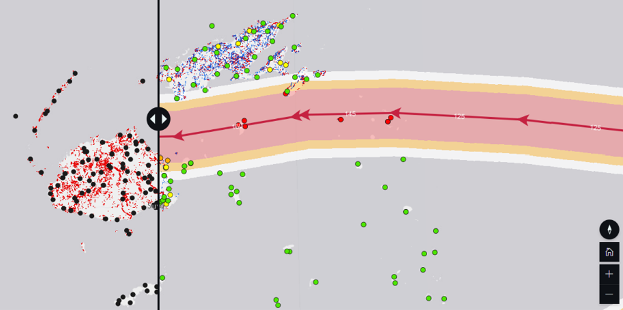
The lack of sanitation in health care facilities can contribute to the spread of infections and reduce the dignity of those who are seeking help. Extreme weather events can damage the infrastructure of healthcare facilities, making the situation even more critical for those seeking care. Our students Carolina Barcelos, Yassine Labbassi, Mrunalini Pise, Hossain M. Sarowar and Nimisha Verma analyzed parts of an survey on healthcare facilities in Fiji to assess Fiji`s sanitation situation against the United Nations’ Sustainable Development Goal 6 / target 6.2 that "all health care facilities provide all users with adequate functioning sanitation facilities". To facilitate an analysis at multiple scales, students integrated data from the Secretariat of the Pacific Community to construe the path of TC Winston in 2016, created interactive maps and built a storymap. The group highlighted the complex and challenging situation that Fiji is facing, with very few healthcare facilities providing sufficient toilets, and with the Northern parts of the main island strongly impacted by the cyclone (Figure 2).
The students recommend the implementation of extreme weather-resistant toilets, and to extend the Revitalising Informal Settlements and their Environments (RISE) programme to more provinces. Besides, they recommend the use of their Storymap to help decision-makers at local, regional, national levels.
Why we need multidisciplinary and international teamwork in dealing with global challenges
Addressing global challenges through a multi- and interdisciplinary lens allows for a more comprehensive understanding of a phenomenon. This helps not only to unpack and understand relations between different aspects, but also how these can be measured, mapped, modeled, analyzed, or monitored.
Effects of global challenges vary geographically. Exchanging different kinds of experiential and international knowledge provides different perspectives on how global challenges ‚hit the ground‘ and the diversity of possible solutions to prevent, adapt to or mitigate effects. Combining the diversity of perspectives, approaches, and knowledge of our students is more than just the sum of its parts: it can lead to the urgently needed innovations to address global challenges at the local level. This requires an open mind, respect for another way of thinking and working, willingness to learn from one another, and a carefully crafted social contract between the students involved.
Full article available online
This is an abbreved version of an article that is published in the newsletter of the German Working Group Medical Geography and Geographic Health Research (Arbeitskreis Medizinische Geographie und Geographische Gesundheitsforschung) on med-geo.de. Via this link you have access to the full article.
More information on Geo-Health at ITC
ITC is known to be one of the top institutes worldwide in the field of Geo-information science and earth observation. At the ITC Faculty of the University of Twente, we train students to engineer approaches for designing future-oriented solutions to the world's biggest challenges. We encourage our students to participate in public-private partnership projects initiated by ITC and other organizations. Please visit this webpage if you are interested in Geo-Health education at ITC. Research on this topic can be found on our Geo-Health Pure website.
References
Anthonj, C., Amer, S., Pfeffer, K., 2021. How multidisciplinary student groups at ITC at the University of Twente address global GeoHealth challenges with local actions. Newsletter Arbeitskreis Medizinische Geographie und Geographische Gesundheitsforschung in der Deutschen Gesellschaft für Geographie, 2021(1), 7-10.
Biswas, B., Campomanes, F. V, Collazos Cortes, D.F., Durmuş, İ., Mutasha, B.M., Sharma, M., 2021. Analyzing the underlying environmental and socio-economic factors affecting Malaria in Rwanda. Global Challenges – Local Action final project presentation. ITC at the University of Twente, Enschede, The Netherlands. 15 April 2021.
Barcelos, C., Hossain, M.S., Labbassi, Y., Pise, M., Verma, N., 2021. Sanitation conditions of Health Care Facilities in Fiji. Global Challenges – Local Action final project presentation. ITC at the University of Twente, Enschede, The Netherlands. 15 April 2021.


