This course offers the latest knowledge and technology in photogrammetry, Remote Sensing, and digital image processing, empowering you to extract and produce geo-information
In this course, you'll gain both the theoretical knowledge and practical skills to confidently extract geoinformation using established and cutting-edge techniques. You'll also discover how the processes of data acquisition and processing are directly tied to the accuracy of results and their importance in a wide range of applications.
As the world faces growing challenges such as population growth, economic expansion, environmental degradation, and climate change, managing land use and Earth's resources has never been more crucial.
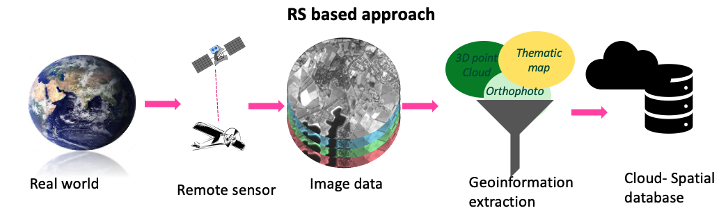
Having access to accurate, up-to-date, and well-structured geoinformation is key to tackling these global challenges and finding the best solutions. Today’s planners, resource managers, and scientists are enthusiastically leveraging high and medium-resolution multispectral images and other data structures like 3D point clouds. These multispectral images are captured by a variety of spaceborne and airborne sensors, including exciting new platforms like drones, while 3D point clouds are created using advanced techniques like laser scanning.
This makes it all the more important—and exciting—to train professionals to expertly extract both thematic and 3D geoinformation from different sensors and scanners, using the latest automated and semi-automated processing environments that are continuously evolving.
For whom is the course relevant?
- Staff from government agencies and private companies with practical professional experience in remote sensing and/or photogrammetry and who wish to become familiar with state-of-the-art knowledge and technology.
- GIS specialists who regularly use digitally acquired spatial reference data are interested in the source and accuracy of these data.
- Staff and researchers from non-geo disciplines who want to employ geoinformation in their research or work would also significantly benefit from this course.
What is the course content?
The course is structured in four sequential modules of three weeks each. The first two modules are concentrated on Remote Sensing topics and the last two on photogrammetric topics. Learning outcomes are defined per module and evaluated progressively at the end of each one.
What will be achieved?
Upon completion of the Remote Sensing modules, you will be able to:
- Select appropriate sensors and image data for geospatial problem-solving
- Apply relevant contrast enhancement for visual and digital image analysis
- Apply spatial and temporal filters to improve image data for visual and digital image analysis
- Calculate indices and ratios for digital image analysis
- Apply different strategies for generating training and validation samples for supervised machine learning classifiers
- Apply various feature selection methods for data dimensionality reduction purposes
- Summarize the main multi-temporal image analysis steps
- Apply Random Forest classifier to classify both single-date and multi-temporal images
- Critically interpret the classification results obtained by applying supervised machine learning classifiers.
Upon completion of the photogrammetry modules, you will be able to:
- Describe the UAV properties and classifications and distinguish the two main mapping applications
- Describe the sensor system properties, output data quality and applications for EO sensors with a focus on laser scanner and mobile mapping systems
- Explain 3D point cloud properties and data quality generated by a laser scanner, and apply basic processing methods on the 3D point clouds dataset for mapping applications
- Differentiate the quality of the positional control and define appropriate required positional accuracies for various applications
- Design flight planning for a specific application
- Understand image orientation procedures (direct and indirect) with a focus on digital aerial images.
- Apply image orientation procedures, point cloud and orthophoto generation procedures, and feature extraction procedures on drone images using the designated software.
- Process aerial oblique images (image orientation, point cloud, orthophoto generation) using the designated software
- Process the multispectral drone images using the designated software.
- Assess the quality of all the procedures mentioned above and the produced data.
About your diploma
Upon successful completion of this course, you will receive a Certificate which will include the name of the course.
Along with your Certificate you will receive a Course Record providing the name, and if applicable, all the subjects studied as part of the course. It states: the course code, subject, exam date, location and the mark awarded.
Admission requirements
Academic level and background
Applicants for this certificate course should have completed their secondary education in a discipline related to the course specialisation and have at least three years of relevant practical experience.
Documentation
The faculty accepts transcripts, degrees and diplomas in the following languages: Dutch, English, and German. It is at the discretion of the faculty to require additional English translations of all documents in other languages as well.
English language
As all courses are given in English, proficiency in the English language is a prerequisite.
If you are a national of one of the countries in this list (PDF), you are exempted from an English language test.
If an English language test cannot be provided, ITC staff members will assess your proficiency to ensure it meets the minimum requirements.
Please note: the requirements when applying for fellowships may vary according to the regulations of the fellowship provider.
English language tests: minimum requirements
Only internationally recognized test results are accepted.
TOEFL Paper-based Test (PBT) | 500 |
TOEFL Internet-based Test | 61 |
British Council / IELTS | 5.5 |
Cambridge | C2 Proficiency / C1 Advanced |
Computer skills
If you lack computer experience we strongly advise you to follow basic courses in your home country.