This course provides the latest knowledge and technology in Remote Sensing and digital image processing, equipping you with the skills to extract and produce high quality geo-information
In this course, you will gain theoretical knowledge and practical skills to extract geoinformation using both established and cutting-edge techniques. You’ll also explore how data acquisition and processing methods directly impact result accuracy and their critical role in various applications.
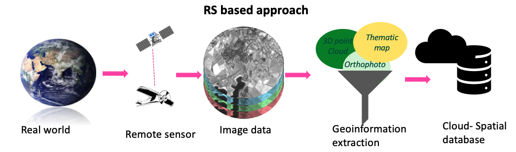
As global challenges such as population growth, economic expansion, environmental degradation, and climate change intensify, the need for accurate, up-to-date geoinformation has never been more urgent. Today’s professionals rely on high- and medium-resolution multispectral images to extract valuable information on land cover, land change, crop quality, yield estimation, and even the nutritional value of crops. These images, captured by various spaceborne sensors, are often acquired over multiple periods to support monitoring and modeling efforts.
This course trains professionals to efficiently extract multi-purpose geoinformation from diverse sensors to meet the growing demand for skilled specialists. You will gain expertise using automated and semi-automated techniques, including machine learning algorithms like Random Forest.
The course is structured into two sequential modules of three weeks each. The first module focuses on digital image preprocessing techniques, while the second delves into advanced image classification methods. By the end of the course, you will be skilled in selecting appropriate sensors for geospatial application, applying digital image enhancement techniques, calculating spectral indices, and using machine learning-based classification methods for remote sensing analysis.
For whom is the course relevant?
- Staff from government agencies and private companies with practical professional experience in remote sensing who looking to update their knowledge and technology with state-of-the-art.
- GIS specialists who use geoinformation extracted from Remote Sensing and need to understand its source and accuracy.
- Professionals and researchers from non-geo disciplines who want to utilize geoinformation in their research or work.
What is the course content?
The course is structured in two sequential modules of three weeks each. Learning outcomes are defined per module and evaluated progressively at the end of each one.
What will be achieved?
Upon completion of the Remote Sensing modules, you will be able to:
- Select appropriate sensors and image data for geospatial problem-solving
- Apply relevant contrast enhancement for visual and digital image analysis
- Apply spatial and temporal filters to improve image data for visual and digital image analysis
- Calculate indices and ratios for digital image analysis
- Apply different strategies for generating training and validation samples for supervised machine learning classifiers
- Apply various feature selection methods for data dimensionality reduction purposes
- Summarize the main multi-temporal image analysis steps
- Apply Random Forest classifier to classify both single-date and multi-temporal images
- Critically interpret the classification results obtained by applying supervised machine learning classifiers.
About your diploma
Upon successful completion of this course, you will receive a Certificate which will include the name of the course.
Along with your Certificate you will receive a Course Record providing the name, and if applicable, all the subjects studied as part of the course. It states: the course code, subject, exam date, location and the mark awarded.
Admission requirements
Academic level and background
Applicants for this certificate course should have completed their secondary education in a discipline related to the course specialisation and have at least three years of relevant practical experience. Some background in geospatial data, remote sensing, or related fields is beneficial.
Documentation
The faculty accepts transcripts, degrees and diplomas in the following languages: Dutch, English, and German. It is at the discretion of the faculty to require additional English translations of all documents in other languages as well.
English language
As all courses are given in English, proficiency in the English language is a prerequisite.
If you are a national of one of the countries in this list (PDF), you are exempted from an English language test.
If an English language test cannot be provided, ITC staff members will assess your proficiency to ensure it meets the minimum requirements.
Please note: the requirements when applying for fellowships may vary according to the regulations of the fellowship provider.
English language tests: minimum requirements
Only internationally recognized test results are accepted.
TOEFL Paper-based Test (PBT) | 500 |
TOEFL Internet-based Test | 61 |
British Council / IELTS | 5.5 |
Cambridge | C2 Proficiency / C1 Advanced |
Computer skills
If you lack computer experience we strongly advise you to follow basic courses in your home country.