INTERESTED IN A CAREER IN GIS / SPATIAL DATA SCIENCE AND BECOMING A GEOSPATIAL PROFESSIONAL?
Geo-information and spatial data science are diverse fields that can lead to many different career paths. At ITC, you will learn the necessary skills to excel in the public or private sector. We will provide you with the advanced knowledge and critical skills needed to become a leader in the field. You can contribute to creating a liveable and sustainable healthy planet and solve some of the world's most pressing challenges - such as climate change, urban planning, food and water security, critical raw materials, land scarcity, and natural disasters - by mastering the acquisition, analysis, and processing of geo-information and earth observation data or through the development and creation of new technologies, methods and tools.
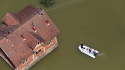
We already live in a geoAI-enabled digital society where geographic information and earth observation data are vital for designing and managing a sustainable, liveable planet. Consequently, we need to be able to develop tools and use and manage the vast quantities of geospatial data that are available for real-time decision-making, monitoring the environment, assessing our earth’s resources, creating disaster-resilient solutions, planning smart cities, quantifying ecosystem services, mapping health risks, and predict changes in our environment. Our planet is changing, and we need to know where it is changing and how it is changing so that we can understand what solutions are needed to create sustainable living environments. This is the ‘science of where’: where are changes taking place, where are stakeholders affected, and where are solutions most effective?
What will you learn
This international Master’s programme is open to a diverse audience of all backgrounds. What all participants have in common is an interest in tackling global challenges with geospatial technologies. The programme equips you with the geospatial skills needed to address the global challenges of today, finding solutions through local actions. You will gain the theoretical knowledge, develop the technical skills, and data competencies to leverage geospatial technologies and data such as remote sensing, to address complex problems and engineer, design or develop innovative and sustainable solutions while also enhancing your professional skills through a mix of individual and international team group work and the chance to develop a wide range of communication skills ranging from blogging, vlogging to formal academic presentations.
During the programme, which is offered fully in English, you will develop various technical and professional skills. There is a global demand for experts in geographic information science and earth observation with skills in GIS, remote sensing, and data science, including artificial intelligence (AI) and machine learning. During your study you will enhance your technical and investigative capabilities while also taking into account the social and cultural context in which you will be applying these skills. This will enable you to translate technical knowledge into actionable policies and vice versa in a global world. You’ll have opportunities to connect with industry professionals through an extensive alumni network, guest lectures, internships, and market and career fairs. All of which will help you develop the skills you need to make your next career move. We provide the opportunities, the rest is up to you!
Request the master's brochure
Specialisations


Courses
We offer a variety of courses that contribute to the well-being of the planet with an emphasis on achieving many sustainable development goals while at the same time developing the necessary geospatial skills needed across different industries.
For a comprehensive overview of all available courses, please visit the specialisations webpages.
MSc thesis
This learning path will bring you to a research topic which you will develop into an individual high-quality MSc research and thesis to define yourself in the field of Geo-information Science and Earth Observation.
Study guide
The study guide contains detailed information on the programme structure, an overview of all programme courses, and detailed course descriptions.
Define your future
Our Master's programme will provide you with the necessary set of foundation courses from which you can build your personal programme, based on a learning pathway under one of our thematic lines or specialisations. For the MSc research and thesis, you are free to select a topic of your choice, enabling you to use this as an opportunity to define yourself in the field of Geo-information Science and Earth Observation.
Career perspectives
During the Master’s in Geo-information Science and Earth Observation, you will interact and learn from expert scientists in the field and have access to our state-of-the-art labs and centres. All over the world, in any industry, there is a growing need for experts in geographic information systems (GIS), spatial data science, and remote sensing. As a GIS specialist with in-depth knowledge and skills in geospatial technologies, you will be a key player in developing and advancing data-driven sustainable solutions to some of the most pressing global issues, such as climate change and energy transition. You could work for a wide range of international non-governmental or corporate organisations, governments, consultancy agencies, research institutes, public service corporations, telecommunications companies, water authorities, and national mapping agencies, to name but a few. This is why 60% of graduates find a job within six months after graduation (90% within one year).
Job opportunities for Geo-Information Specialists
Experts in geo-information systems who can acquire, analyse, and visualise geo-information to develop innovative solutions are in high demand both in the private and public sectors. You can work as a policy advisor, geo-information consultant, GIS analyst, geospatial data scientist, environmental management consultant, remote sensing specialist, data engineer, and more. You can also opt for a career in academia and do a PhD at any university worldwide. Or you can start your own company!
Facilities and laboratories
The Faculty of Geo-Information Science and Earth Observation (ITC) is internationally recognised for its research and capacity development in the field of geo-information science and Earth observation. As a student here, you will have access to first-class facilities and resources such as the Design and interactive space for co-creating, Drone lab, Field labs, Field sites, Geochemical labs, the Geospatial Computing Platform, Open-source software and tools, Remote Sensing and GIS lab, Satellite & sensor database, Spatial Data Visualization & Usability Analysis lab, and the Spectroscopy laboratory. Also, you can work with leading scientists and other experts from the geo-information science and Earth observation domain. It is a great environment where you will expand your network and gain invaluable hands-on experience for your future career!