Center of Expertise in Big Geodata Science (CRIB) is a research and expersite center focusing on better use of cloud computing and big data technologies in research, education, and institutional strengthening activities related to Geo-information Science and Earth Observation.
Our mission is to collect, develop, and share operational know-how to solve large-scale geospatial problems efficiently by using cloud computing and big data tools and methods.
Our vision is to position University of Twente and ITC as a globally renowned center of excellence in geospatial cloud computing and big data science.
Core Team
The Core Team leads the research, development, and capacity building activities of CRIB.


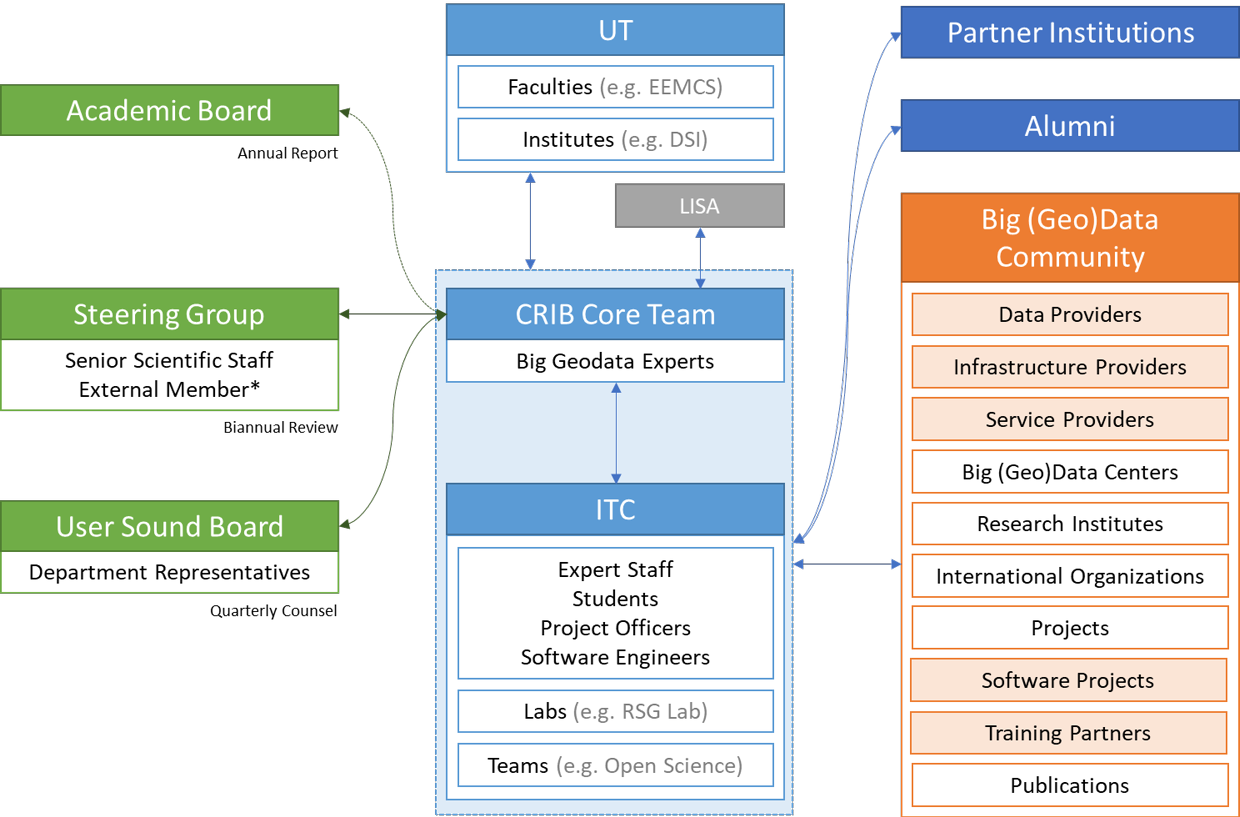
Structure
CRIB has strong connections and collaborations with other ITC and UT units, as well as national and international partners and our alumni:
Activities
RESEARCH
CRIB actively take part in the research projects in various domains and leads projects on big geodata and cloud computing technologies, including efficient geocomputing and open (geo)data management, inline with its mission and vision. We advocate that the research projects should include the cloud computing and big data technologies as needed, from the proposal stage onwards, budget appropriately, and ensure that the infrastructure available will be optimally utilized. Provision of consultancy and advisory services for the integration and improved use of the technology is therefore crucial and they are amongst the main tasks of CRIB.
Infrastructure
Better use of cloud computing and big data technologies requires an infrastructure that is not limited to research and education needs, but is also available for personal capacity development activities. The infrastructure should fit the purpose, be efficient, easily accessible, user-friendly, and cost-effective. It should also utilize already existing assets and employ a hybrid approach that benefits from both local and remote (e.g. cloud) resources. CRIB developed and currently operates the Geospatial Computing Platform, which not only serves for big data computing purposes, but also provides all necessary infrastructure for a wide-range of geospatial and EO computing needs, including machine learning and AI.
Knowledge Development
Better and wide-spread use of big geodata technology requires improving the existing expert knowledge by providing theoretical and hands-on training to interested parties, and raising the overall familiarity with the technology. CRIB organizes short courses and hands-on training on geospatial cloud computing and big data tools and technologies to improve knowledge, Big Geodata Talks to share domain-specific experience of the expert organisations, and Big Geodata Meetings to facilitate discussion and problem solving. The center also publishes a monthly Big Geodata Newsletter.
Networking
Geospatial cloud computing and big data domains are evolving rapidly. To keep up with its progress, it is important to closely monitor the developments, especially related to data resources, analysis methods, tools, and platforms. CRIB closely follows the activities of the data providers, service providers, research institutions, donor organisations, and international bodies, and informs interested parties though its communication channels, such as @BigGeodata and Big Geodata Newsletter.
Steering Committee
The Steering Committee consists of 3 to 5 members, on a 2-year rotation, chosen among ITC's scientific staff and one external member. The committee reviews CRIB's strategy and reflects on its functioning. It also reviews the CRIB Annual Report and ensures it is entered on the agenda of ITC's Academic Board.


User Sound Board
The User Sound Board consists of one staff member per scientific department of ITC. The members are expert in big geodata science in various domains. They function as communication channels into departments and their big data challanges. The board meets quarterly to discuss needs and wishes and aim to schedule developments in CRIB's activities.