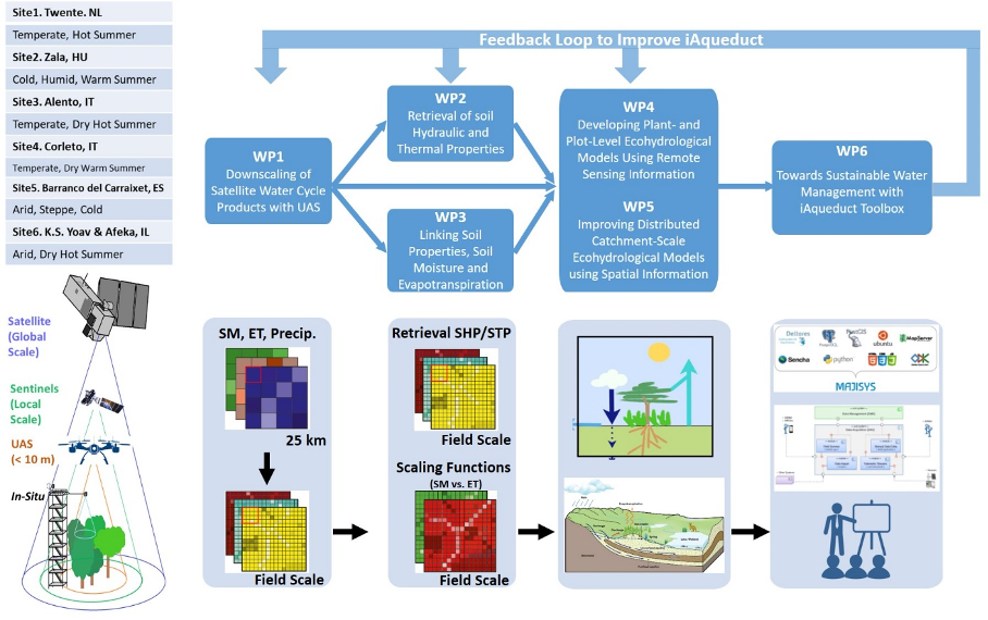
The figure describes the iAqueduct framework of methodologies and approaches. It includes six closely connected working packages (WPs). WP1 deals with the scaling from global satellite water cycle products to field-scale water states, which includes both the surface and profile information on soil water states. WP2 will apply pedotransfer functions to derive local field specific SHP/STP properties for the modelling of soil water and heat dynamics at field-scale precision. WP3 attempts to retrieve field- and grid-specific relationship functions between soil properties, soil moisture, and evapotranspiration. WP4 is expected to advance ecohydrological modelling by intercomparing models with different levels of complexity, in terms of the soil–water–vegetation–atmosphere transfer processes involved. WP5 will then demonstrate the benefits in closing water cycle gaps from the global to local scale, in terms of how to effectively handle spatiotemporal data (from in situ, UAS, and satellites), regarding ecohydrological model calibrations and accuracy evaluations of simulated spatial patterns of ecohydrological variables. WP6 is about disseminating and communicating generated knowledge, data, and tools to water managers, companies, and farmers for actual sustainable water management of their responsible domains.