This study area partly belongs to the “Cilento and Vallo di Diano” National Park, the largest national park in Italy, and is included as a representative site within the UNESCO-HELP program. The Alento River Catchment is usually split in the Upper Alento, a hilly and mountain marginal area that suffered from severe land abandonment and subsequent land-use changes, and the Lower Alento, characterized by a flourishing economy especially because of tourism along the entire coastline. A system of barrages, the largest being the “Piano della Rocca” earthen dam, were built and is managed by the “Velia” Bureau of Reclamation to increase irrigated agriculture and the quality of livestock methods, hence reducing the gap between the two parts of the catchment.
However, as in most water-stressed zones of the Mediterranean belt, this area is experiencing an excessive demand for water partly because of the competition among different users, which could yield conflicts among them, especially during summer. Decision-makers and stakeholders are now concerned about future benefits and constraints deriving from the changes observed in land uses and climate seasonality, and are therefore interested in addressing the following main issues: a) Predicting the storage capacity of the artificial reservoirs in view of projected climate and land-use changes so as to meet short- and medium-term water requirements from households, agriculture, tourism, and hydropower generation; b) promoting the most effective demand-side adaptation options; and c) identifying optimal land resource management to ensure adequate water availability to all sectors, reduce fire risk during the prolonged dry seasons, and, at the same time, alleviate natural hazards, such as flooding and soil erosion, during the wet season.
To meet these needs, the Alento River catchment is becoming a science-driven critical zone observatory (CZO), with a major aim of supporting the issues of rural environmental protection and sustainable management of natural resources. The “Alento” CZO not only relies on background geological, pedological, and hydrological studies carried out over the last decades but also benefits from a series of investigations currently underway in the Upper Alento catchment. Since 2016, wireless sensor networks (WSNs) and cosmic-ray neutron probes (CRNPs) monitor soil moisture in two small sub-catchments, named MFC2 and GOR1, having different topographic, pedological, and land-use characteristics as well as slightly different weather conditions.

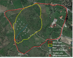
On the left: Alento upper catchment (with the black boundary), as well as the locations of MFC1, MFC2, and GOR1 sub-catchments. On the right: the MFC2 area, and the detailed locations of SoilNet units, the cosmic ray probe and the surface hydrological boundaries.