Enzo Campomanes is a PhD candidate at ITC, who first encountered the Faculty during a 2016 conference while working in the Philippines. Inspired by his positive experience, he returned to pursue a Master’s in Geo-Information Science and Earth Observation in 2020.
Originally trained in Computer Science, Enzo transitioned into GIS and remote sensing through a research project involving LIDAR. His Thesis focused on food access in Ethiopia using deep learning and geospatial data, though his current PhD work on slum mapping in Africa represents a shift in focus.
How did you find out about the ITC?
I visited the ITC for the first time in 2016 for a conference, the GEOBIA (Geographic Object-Based Image Analysis). At that time, I used to work in the Philippines as a researcher. We submitted a paper to the conference and it got accepted and got funding. I was at ITC for a week and a half. During that experience I met really nice people and thought, “if I do decide to do a Master’s this would be the place to do it”.
My journey at ITC started in 2020, when I applied for the Master’s in Geo Information Science and Earth Observation and secured the ITC excellence scholarship.
Can you tell me more about your background of this research you were doing your Bachelor's?
I did a Bachelor’s in Computer Science in the Philippines, but I didn't really want to work in the tech industry to become a software developer. Luckily, there was the Phil-LiDAR 2 project, a research project in my university about using LIDAR for natural resources management. I had no clue what LIDAR was, and had no clue about natural resources, but I knew how to program, and I fit the profile: they were looking for technical people that were willing to travel.
I started to work in that position and received training in LiDAR processing, GIS, remote sensing, satellite imagery... concepts that were completely new for me. After the training, I started to like this field and spent three years working in this project and three more years in the Center for Environmental Informatics (CENVI) at the University of the Philippines Cebu.
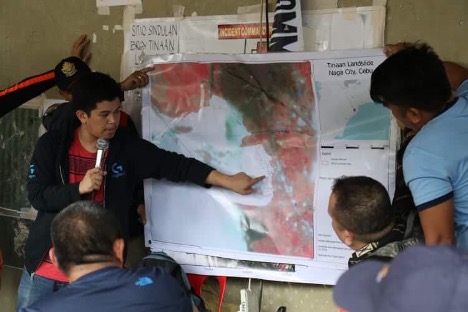
This picture was part of my work with CENVI when we aided first responders in their rapid search and retrieval using earth observation and geospatial analysis.
My interest in GIS, remote sensing and the whole GEO field grew over time. I knew that I wanted to be in this realm and use my computer science background with topics like artificial intelligence and machine learning.
And then you thought maybe doing a Master's is a nice next step...
Our project was coming to an end and I wanted to do something different. I realized while I was in that job that I wanted to teach. Whenever we'd have high school or bachelor students come to our office asking for help with their thesis topics, I realized that I liked helping out and teaching Earth Observation, Geo Information Science and Remote Sensing, with things such as helping students map their study area, collect their data, or even just plotting their data on a map; small experiences of helping out which made me even more interested.
I thought that going into the academe and teaching would be a fun experience, and then I decided to do a Master’s.
What was your favourite course during the Master’s?
Well, I would say the "Earth Observation for Natural Resources Management" course.
I never had any formal training or classes on Earth observation or remote sensing before. Everything I knew was based on experience, reading, and talking with people who had expertise in the field. So, having a class that really taught different aspects, like remote sensing and radar, was great.
It was funny because they were teaching about LIDAR and object-based image analysis—which was what I had been doing for six years—I realized that I never fully understood if what I was doing was correct.
My favourite elective course was "Advanced Image Analysis," where I learned machine learning and deep learning for remote sensing.
Did that course influence your Thesis topic?
Not in my case, as my Thesis didn’t involve any remote sensing data at all. It was mostly based on geospatial surveys and data, but no satellite imagery.
I applied to the Food Access topic supervised by Professor Andy Nelson. It was very open-ended, allowing me to choose any country I wanted and decide what aspect of food access to focus on.
How did your Thesis develop?
Andy and I discussed possible research questions at the beginning. He forwarded me a paper that used field data from the Demographic Health Survey (DHS), which I was already familiar with from the Global Challenges, Local Action (GCLA) course during the first year of the Master’s. The paper used DHS data, the Relative Wealth Index, satellite imagery, and geospatial data to extrapolate wealth across different areas using Deep Learning. He suggested that this approach might be interesting for me to explore but shifting the focus towards Food Access instead. I found the Living Standards Measurement Study (LSMS) dataset for Ethiopia to apply to my Thesis.
I started working on it over the summer because I wanted to avoid data availability issues later on, which is a common problem for many Thesis projects. I made sure I had ideas and access to the necessary data. When I brought this to Andy, he agreed that it was a good direction, so we decided to proceed with it.
Can you tell us more about your Thesis?
Food access can be broken down into three dimensions: physical, social, and economic access. However, social access, which relates to preferences for socially acceptable food, was hard to measure comprehensively due to a lack of data. We focused on physical and economic access, which had available data, such as ownership of assets (economic access) and the location of enumeration areas relative to roads and markets (physical access).
The Thesis had three phases. First, we created an index from the survey data, something similar to the Relative Wealth Index but focused on food access—essentially a food access index. This index was calculated at each survey point. This index then served as the training data for the machine learning model.
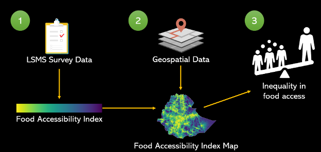
This figure summarizes how the three phases of my thesis come together.
We discovered some notable things. Through principal component analysis of the survey data, we found that economic access had more weight than physical access, which was quite interesting. This aligned with Andy’s previous work, where he argued that physical access alone isn't sufficient. Many studies focus on physical access—using complex calculations, networks, etc.—but often overlook economic access. Our thesis highlighted the importance of considering both dimensions.For example, even if someone lives near a road, if they can't afford the fare to travel to the market, or if they can reach the market but can't afford the food there, they still don't have access. This was a key novelty of the thesis: incorporating and quantifying both physical and economic access to food.
In the final phase, we extrapolated the data and analyzed food access across different urban-rural catchment areas, known as URCAs. These URCAs are classified based on travel time to a large city (e.g., less than one hour, one to two hours, etc.). We wanted to see how food access varied within these areas, particularly in peri-urban (less than one hour) and rural areas.As expected, food access tended to decrease the further away you were from the city, reinforcing the idea that proximity to the city alone isn't the sole determinant of access.
After mapping the average food access in Ethiopia, Andy suggested incorporating a temporal analysis to understand how food access fluctuates over time. We discovered that certain months had consistently low food access across most URCAs, particularly during the start of the planting season. This made sense as food supply was low before harvest, impacting market availability. By relating our findings to the Ethiopian crop calendar, we observed that food access improved as the harvest season progressed.
You published a paper based on your Thesis and then started a PhD, right?
Yes, we submitted the paper in February 2023, and I started my PhD in March 2023. While I was working on my PhD, I received the first round of feedback from the journal review, made revisions, and then went through a second round of review. Then in late October 2023, the paper was finally accepted and published.
Was your PhD related to the thesis?
Not really—it's a bit of a stretch. My PhD focuses on mapping slums in Africa. While my Master’s thesis dealt with urban and peri-urban areas, it wasn't directly about vegetation or crop health; it focused more on the people and their access to resources, which somewhat relates to my current work. The skills I developed during my thesis, like using PCA, random forests, and generalized additive models, are relevant.
My background in computer science also helped, especially when I took the Advanced Image Analysis course, where I learned how to train deep learning models. This technical experience has been useful in my PhD, although now I mostly use Python instead of R, which I got really into during my Master’s.
Deep learning and AI are hot topics right now. How do you see the rapid advancements in AI affecting your work?
It’s challenging to keep up. For example, I started my PhD with a mini project called SlumGPT, inspired by ChatGPT, where you could ask where are the slums in a city and get a map in response. It was a cool idea, but it quickly became too big to manage within the scope of my PhD.
Now, I’m focusing on data-centric AI for slum mapping, which is still a fresh area, but it’s tough to stay ahead of the rapid changes in the field. I recently saw a preprint of something similar to SlumGPT, which shows how quickly ideas evolve in AI. Even though I had a vision early on, the field moves so fast that it’s a constant challenge to stay novel while aligning with the objectives of my project.
How was it like moving to the Netherlands and starting to study at ITC? How did you experience that change?
It was especially difficult for me, as I hadn’t gone to school for almost seven years. I did the first month online from the Philippines, and then I came here and the pandemic started so we had to stay in quarantine.
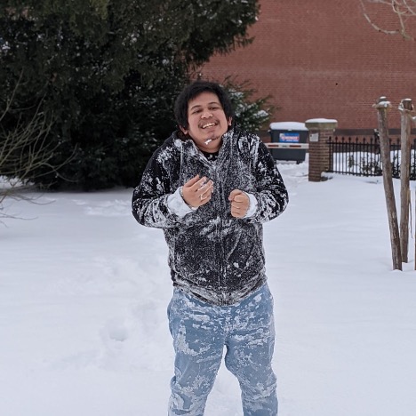
It was tough in the beginning, I didn’t go out at all. I didn’t even go to Amsterdam until a year and a half later, because I was busy with assignments and projects. During the summer I travelled a bit, but then came back and started working on the thesis. It was tough, but I would say the quality of life is a lot better than the Philippines, and I don’t really mind the cold (picture below for some proof).
Do you have some advice for future students?
Relax. Take it day by day. I think I wasn’t able to do that. I took things so seriously. I mean, yeah, some people and my friends would say, “Oh yeah, but it paid off because you ended up with a nice thesis...” But sometimes I think maybe I should have just enjoyed my time more.


