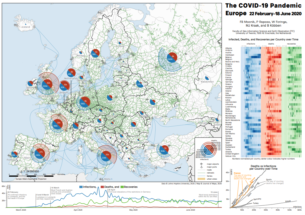
The winner of the GIN-Cartography Prize 2020 is an entry by five researchers from the Department of Geo-Information Processing (ITC Faculty, UTwente). Geo-Informatie Nederland (GIN) announced this on Tuesday afternoon, November 24, during an online event. The competition was created to honor and value professionals, to stimulate innovation and to bind the next generation to the geo-domain.
The Covid-19 pandemic
“When portraying a global pandemic like COVID-19, several challenges simultaneously play a role,” says Professor Menno-Jan Kraak. “For example, in addition to the global picture, you must also pay attention to local situations with several thematic variables (for example, the number of infections and the number of deaths) that not only change over time, but also vary from ‘very little’ to ‘a lot’.
“Our maps of Europe, China and North America are an example of how to visualize this complex matter, with each country/region having a combined diagram showing the number of infections and deaths. This is supplemented with a temporal strip diagram of each variable representing the (normalized) numbers and a temporal line diagram with the accumulated numbers” explains Professor Kraak.
Complete picture
The current pandemic affects large parts of the world and its development in space and time is complex. This highlights the importance to communicate the complete picture to medical professionals and policymakers who need insight in the data. “Besides professionals, the maps can be especially useful for print media like magazines and newspapers”, says researcher and Assistant Professor Mocnik, “These maps help communicating where hotspots of the pandemic are and how they develop over time.” Only when these aspects are set into a mutual context, the numbers are connected into a coherent story of the ongoing COVID-19 pandemic.
Motivation from the jury
About the maps of Menno-Jan Kraak and his colleagues: “This submission shows that the work of the cartographers is not limited by the map section but that they are able to present themselves as all-round data visualization specialists. It places the map in a long tradition”, says jury chairman Edward Mac Gillavry (Webmapper).
Commenting on the COVID-19 Pandemic maps, Professor Kraak says: “The main challenge was the enormous range of data, time scale and geography. We struggled enormously to bring these things together in the maps.” You can inspect the winning maps over here. The awarding ceremony (in Dutch) can be watched via this video.
More Information
The maps are part of a publication titled “Epidemics and pandemics in maps – the case of COVID-19”, which has been published in the Journal of Maps and can be read online. The maps are open access and free to use. The researchers, Franz-Benjamin Mocnik, Paulo Raposo, Wim Feringa, Barend Köbben and Menno-Jan Kraak are all part of the Department of Geo-Information Processing (GIP; faculty of ITC).


