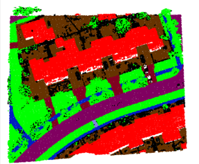
Description: Maps are quickly becoming outdated, about 10 % of the objects change annually. This project focuses on methods to automatically interpret newly acquired sensor data to detect and to update the changed objects in the digital map. The sensor data includes high-resolution 2D aerial image data and 3D laser scanner data. Our approach is to use the existing (old) digital maps to learn how various objects appear in these 2D and 3D datasets. The first step is to design a fusion step between nationwide map data and sensor data to be able to generate a massive training dataset. The second step is to set up a deep learning network for the classification of the sensor data into the learned map classes. The third step handles the incorporation of the detected changes in order to update the map.
Partners: Miramap Aerial Surveys, NEO BV, Het Waterschapshuis, Waterschap Drents Overijsselse Delta, Netherlands Red Cross 510 Global, SVB-BGT, RVO
Sponsor: NWO, Applied and Engineering Sciences (AES)
PhD: Jiao, Anjanappa
Contacts:


