Description: Glaciers are under pressure in the current climate warming trend. The aerial extent and the mass balance, a measure of mass loss or mass gain of a glacier are representative of the “health state” of a glacier. They are recognized as Essential Climate Variables by the World Meteorological Organization. Due to the sheer number of glaciers of roughly 200.000 worldwide and their inaccessibility, satellite data has been proven as a valuable source to map glaciers around the globe.
In MASSIVE, the project team aims to improve glacier mapping and surface glacier mass balance estimation techniques with the help of machine learning, especially deep learning. We will develop the methodology for glaciers in Norway, Svalbard, the European Alps and the Himalayas and then expand it to regions with different glacier characteristics.
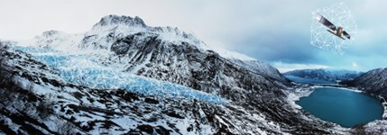
Engabreen, a glacier branch of Svartisen situated in the Nordland county, Northern Norway. Illustration: MASSIVE (Data processing) / Photo: T. Schellenberger
Partners: University of Oslo, Norway; Institute for Earth Observation, EURAC, Italy; The Norwegian Water Resources and Energy Directorate (NVE), Norway; Statkraft, Norway.
PhD: Maslov
Contacts:

