The population of African elephants is decreasing every year due to poaching and habitat fragmentation. In order to preserve this endangered species, it is vital to monitor them accurately. The traditional way to do it is by aerial surveys; however, this method often leads to miscounting. Aerial surveys can also be costly and logistically complicated, due to refuelling stops and multiple national permissions if a border area is observed.
To tackle this issue, a former PhD from the University of Oxford, Dr Isla Duporge, reached out to Dr Tiejun Wang, Associate Professor at the Natural Resources department from the ITC Faculty. "When Isla contacted me, I was well aware of the importance of the first collaboration between the University of Oxford and the ITC Faculty" stated Tiejun. Dr Wang started to supervise Dr Duporge's PhD research, investigating the feasibility of using high-resolution satellite imagery to detect wildlife species with deep learning. The study had one main objective: successfully using satellite imagery and automatic detection could be used to replace aerial surveys and prevent all of the previously mentioned problems that are carried out by this method, as satellites do not disturb wildlife and they cover larger territories than aerial surveys.
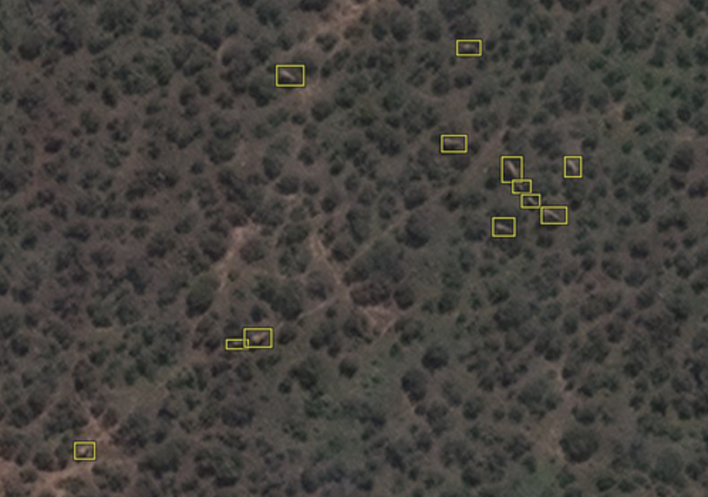
Example of elephant labels in WorldView-3 satellite imagery (Credit: Satellite image (c) 2020 Maxar Technologies)
This research marked a milestone, not only by representing the first collaboration between the University of Oxford and the ITC Faculty but also by showcasing the use of deep learning to preserve wildlife. Other studies have been conducted before, showing methods that mainly work in homogenous environments, where the colour of the species clearly differs from the background. However, in this paper, the results demonstrate that it is possible to automate the detection of elephants in high-resolution satellite images in both homogeneous and heterogeneous backgrounds using artificial intelligence.
Object detection works similarly to face recognition, where the machine learns from a set of images. As Tiejun explains, "Thanks to advanced deep learning algorithms and powerful computers, detection accuracy is comparable to human detection capabilities. Within a few seconds, the computer can scan a large image and identify the elephants. If this technology continues to develop at this pace, in the future we will be able to detect other animal species". The AI learns from observing samples of images. The more samples you have, the more potential the machine has to identify new objects. However, this technology comes with a challenge; identifying and labelling the elephants to use them as an input for the model and help the computer learn what an elephant looks like. "To make the model more robust, the variety of the sample needs to be increased, as elephants are very particular; they often take dust baths and mud baths to cool down their bodies, so their colours adapt to their environment. They may look with a different colour depending on the country where they locate" explains Tiejun.
This research article was supported by the DigitalGlobe Foundation (Maxar Technologies) and the European Space Agency, and became one of the top-cited and top-downloaded articles on Wiley for the year 2020-2021. Contact Dr Wang for more information:
At the NRS Department, we use satellite data to protect wildlife. These data are key to preserving the environment, in this case, by tracking and monitoring elephants. Click here for more on our education on systems approaches for the management of Natural Resources.
On August 12th, we celebrate World Elephant Day to help protect elephants from the numerous threats they face. Visit their website for more information.