Studying the dynamic and intertwined urban processes, the formation, evolution, transition and deformation of various urban entities, has never been straightforward. These urbanization processes are partly hidden within, yet still manifested by, the physical forms of cities. In order to extend our scope of knowledge about city forms, we can shift our view away from the ground to a synoptic perspective so that the typology of physical patterns can be systematically examined.
Pioneered by early efforts of geographers Otto Schlüter and Michael Robert Günter Conzen, studying the urban morphology at the city scale brings the opportunities to understand the hiatus and growth of cities by only looking at their physical forms (Figure 1). Yet, these efforts were largely qualitative and relied on roughly depicted urban forms 1.
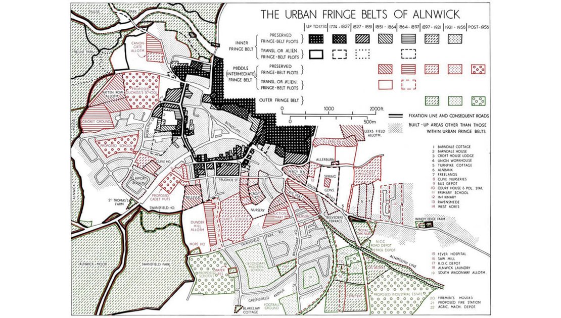
Figure 1. Michael Robert Günter Conzen’s early time effort in 1960s of qualitatively identifying urban morphological types, which happened to correspond to different phases of urban development history.
For an improved scientific understanding of urban morphology, the quantitative depiction of urban elements such as buildings, plots and streets are demanded. Today, we do have data about urban elements at various levels of details in digital format, which we can feed into digital models to characterize urban morphological types, and further link physical forms to different aspect of cities in a quantitative manner. Here, we specifically show how physical forms of cities can be quantified and linked to different aspect of cities (Figure 2), such as historical development and socioeconomic status of cites, which requires a lot of computation power but can be deployed on the Geospatial Computing Platform.
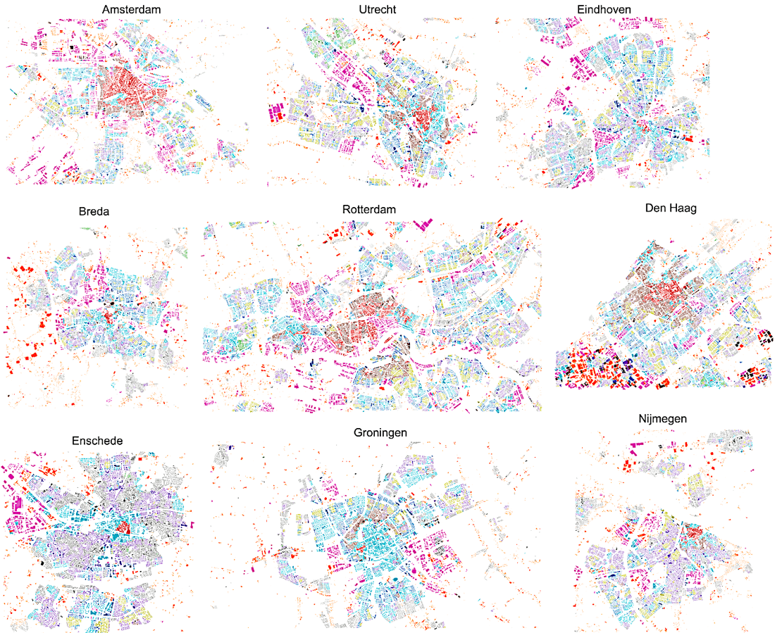
Figure 2. Today’s potential of quantitatively classify urban morphological types in terms of building morphology, which again shows urban footprint developed in history, such as older buildings are recognized as one type (encoded in red) in the centres of various cities in the Netherlands.
We use buildings as one of the major urban elements to understand how different aspects of cities can be manifested only by characterizing urban morphological types in terms of building morphology. We follow a 3-step technical approach to accomplish this:
- Building extraction from satellite image data.
- Measuring building morphology by adopting various predefined morphometrics applicable to building footprint polygons extracted.
- Classifying measured building morphology into morphological types (Figure 3), which can be linked to socioeconomic status of cities as well as historical development processes (Figure 4).
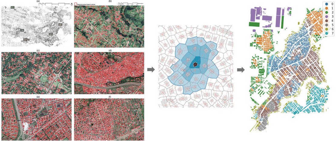
Figure 3. The technical steps of extracting urban elements -- buildings in this case, measuring their morphology, and classifying the measured characteristics into morphological types.
The 3-step approach can be applied to an entire city, which can already involve hundreds of thousands of buildings, or even over a million buildings in a large city. Additionally, we also attempt to study morphological patterns over several cities. The Geospatial Computing Platform is essential to distribute our computational tasks in order to execute this. More specifically, the steps of extracting millions of buildings using Convolutional Neural Networks, computing morphometrics such as building shape, size, inter-building distance, alignment, spatial variance of these metrics, etc, at each building location, as well as classifying a large multi-dimensional dataset are all requiring substantial amount of computational resources. The figure below speaks more about how extracted buildings are measured, classified and related to different aspect of cities.
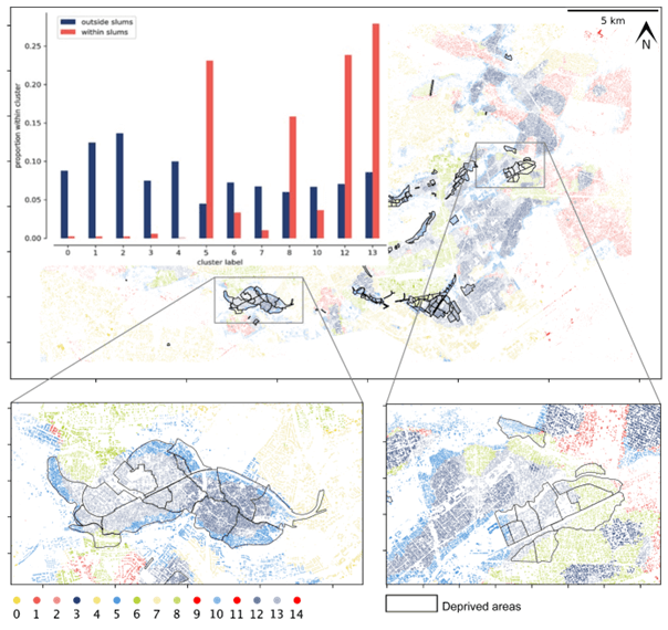
Figure 4. Urban morphological types also reflect socioeconomic status of cities that poor neighbourhoods are more or less dominated by a few types of urban morphology.
The container assigned by Geospatial Computing Platform provides a very clean and powerful computation unit that can easily handle large scale image analysis, and also spatial analysis with different data formats. As mentioned above, our research can easily involve high resolution remote sensing data with pixel size of 0.6-1.2 m at the scale of entire cities, and across multiple cities. Once the buildings are extracted, the computation of morphometrics requires spatial neighbourhood operations over these millions of data points and produces tons of data points with high dimensionality as each of the building are computed with nearly a hundred of metrics. Classifying these data points again highlights the potential of the Geospatial Computing Platform in handling large datasets.
For more information:
1. Wang, J., Georganos, S., Kuffer, M., Abascal, A., and Vanhuysse, S. (2022). On the knowledge gain of urban morphology from space. Computers, environment and urban systems, 95, Article 101831. doi:10.1016/j.compenvurbsys.2022.101831
2. Wang, J., Fleischmann, M., Venerandi, A., Romice, O., Kuffer, M., and Porta, S. (2023). EO + Morphometrics: Understanding cities through urban morphology at large scale. Landscape and urban planning, 233, Article 104691. doi:10.1016/j.landurbplan.2023.104691