Climate extremes pose a threat to terrestrial ecosystem carbon sequestration, imperiling the EU's aim of achieving climate neutrality by 2050. The creation of an open digital twin of the soil-plant system serves to monitor and forecast the repercussions of extreme events on ecosystem functionality. Such a digital twin yields valuable insights that can inform strategies and policies to bolster ecosystem resilience against global climate shifts.
Comprising an integrated workflow, the soil-plant digital twin incorporates a data assimilation framework merging observations with the process-based model STEMMUS-SCOPE. Moreover, this digital twin will be complemented by an interactive and adaptable platform, empowering users to devise and assess what-if scenarios. Notably, this open soil-plant digital twin adheres to Open Science and FAIR principles, ensuring the accessibility and usability of both data and research software. Within this framework, we elucidate how our recently developed STEMMUS-SCOPE model contributes to the open digital twin of the soil-plant system and elaborate on our efforts to enhance the FAIRness of the existing STEMMUS-SCOPE software. We demonstrate the foundational elements of a soil-plant digital twin and underscore the significance of FAIR-enabling digital technologies in rendering research endeavors reproducible and reusable, fostering the exchange of software, data, and knowledge.
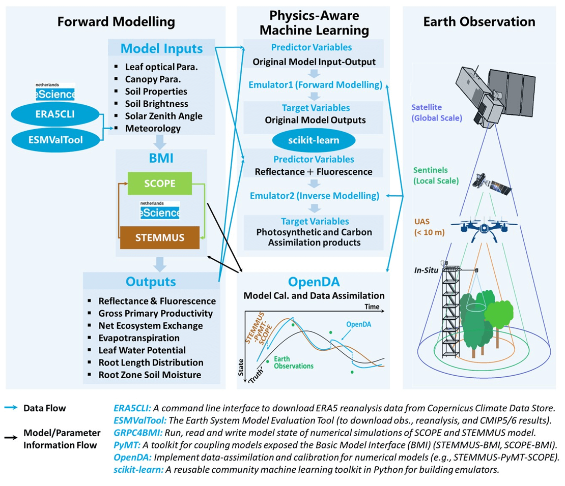 Figure 1. Conceptual workflow of the soil-plant digital twin.
The digital infrastructure for the soil-plant digital twin is presented in Figure 2, which includes the soil-plant digital twin engine (i.e., the soil-plant model, data assimilation and EO), as well as the interactive and configurable platform. With this platform, users can select study areas and time periods for running the soil-plant model. They can also use their own observation data to update the states and parameters of the soil-plant system via data assimilation. Through OpenDA, users can further interact with and experience the physical system’s sensitivities, uncertainties, and fallibilities.
The Geospatial Computing Platform is an indispensable part of this Open Soil-Plant Digital Twin, serving as the user interface (i.e., front-end), wherein a Jupyter notebook is initiated with a basic workflow for running STEMMUS-SCOPE model when the study area and simulation period are defined by users. Furthermore, the computing platform provides the infrastructure needed to develop and test the workflow for running STEMMUS-SCOPE and its emulators. After the testing is successful, SURF High-Performance Computing facility will then be used to upscale the developed workflow from point-scale to regional, and continental scales.
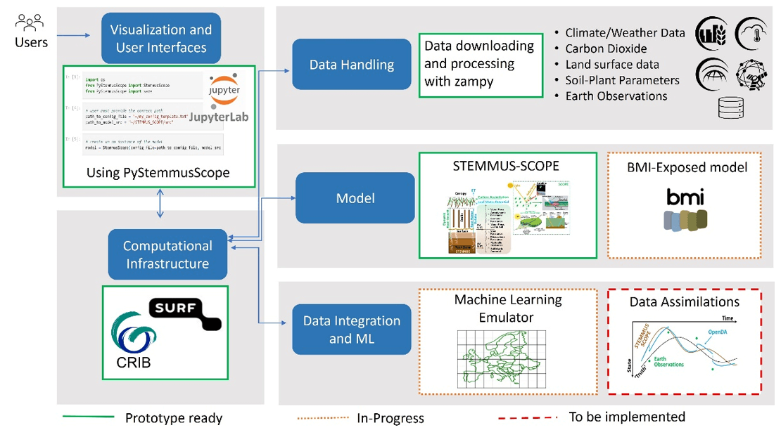
Figure 2. The digital infrastructure of the open soil-plant digital twin.
The Centre of Expertise in Big Geodata Science (CRIB) has been extremely instrumental for supporting the joint implementation of research/project, education, and capacity building. So far, CRIB has helped created shared folders for five research projects, three WREM courses, as well as two capacity building projects. In fact, CRIB serves as a vehicle to integrate research, education, and institutional strengthening in a continuous and repeating cycle of knowledge development and application. For example:
- Scientific quest for understanding the drought response of agricultural and natural ecosystems has fuelled the development of the soil-plant digital twin, which has been implemented on the Geospatial Computing Platform and applied in teaching.
- Students feedback the performance of the digital twin in understanding the response of ecosystems to drought events by comparing model simulations with in-situ measurements.
- The identified model-observation deficiency is analysed and provides evidences to form hypotheses for improving the soil-plant digital twin. The lab and field experiments are then designed and proposed to testify these hypotheses.
- These hypotheses/questions, testable predictions, and experiments feedback into new project proposals. The updated soil-plant digital twin together with new data and applications are then used to renew the course contents.
For more information:
Digital twin approach for the soil-plant-atmosphere continuum: think big, model small
https://frontiersin.org/journals/science/articles/10.3389/fsci.2024.1376950/full
WUNDER: Water use and drought ecohydrological responses of agricultural and nature ecosystems in the Netherlands.
EcoExtreML: Accelerating process understanding for ecosystem functioning under extreme climates with physics-aware machine learning.
iAqueduct: An integrative information aqueduct to close the gaps between global satellite observation of water cycle and local sustainable management of water resources.