Very high-resolution (VHR) optical satellite imagery offers significant potential for detailed land cover mapping. However, terrain shadows, which appear dark and lack texture and detail, are especially acute at low solar elevations. These shadows hinder the creation of spatially complete and accurate land cover maps, particularly in rugged mountainous environments. While many methods have been proposed to mitigate terrain shadows in remote sensing, they either perform insufficient shadow reduction or rely on high-resolution digital elevation models which are often unavailable for VHR image shadow mitigation.
We proposed a bi-temporal image fusion approach to mitigate terrain shadows in VHR satellite imagery. This fusion is applied to improve the mapping of evergreen conifers in temperate mixed mountain forests. The evaluation of the effectiveness of our approach was conducted on the Geospatial Computing Platform of CRIB, enabling efficient performance over large areas. Results confirm its ability to reduce terrain shadows and enhance the detection of evergreen conifers in shaded areas.

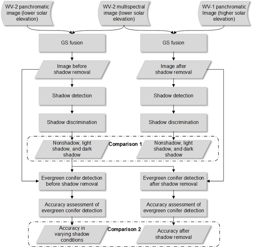
Figure 1. Workflow for mitigating terrain shadows using bi-temporal image fusion, evaluated by comparing shadow proportions and evergreen conifer detection before and after mitigation.
This research integrates high-resolution WorldView satellite imagery and deep learning models to detect evergreen conifers in mountainous regions. A set of leaf-off WorldView-1 (WV-1) and WorldView-2 (WV-2) images were collected across four study sites within the giant panda habitat. The images were geometrically corrected to ensure consistency across different acquisition dates. A bi-temporal image fusion approach was employed to mitigate terrain shadows using the Gram-Schmidt algorithm. To evaluate the effectiveness of our shadow mitigation approach, a shadow detection method was developed to detect terrain shadows before and after shadow mitigation.

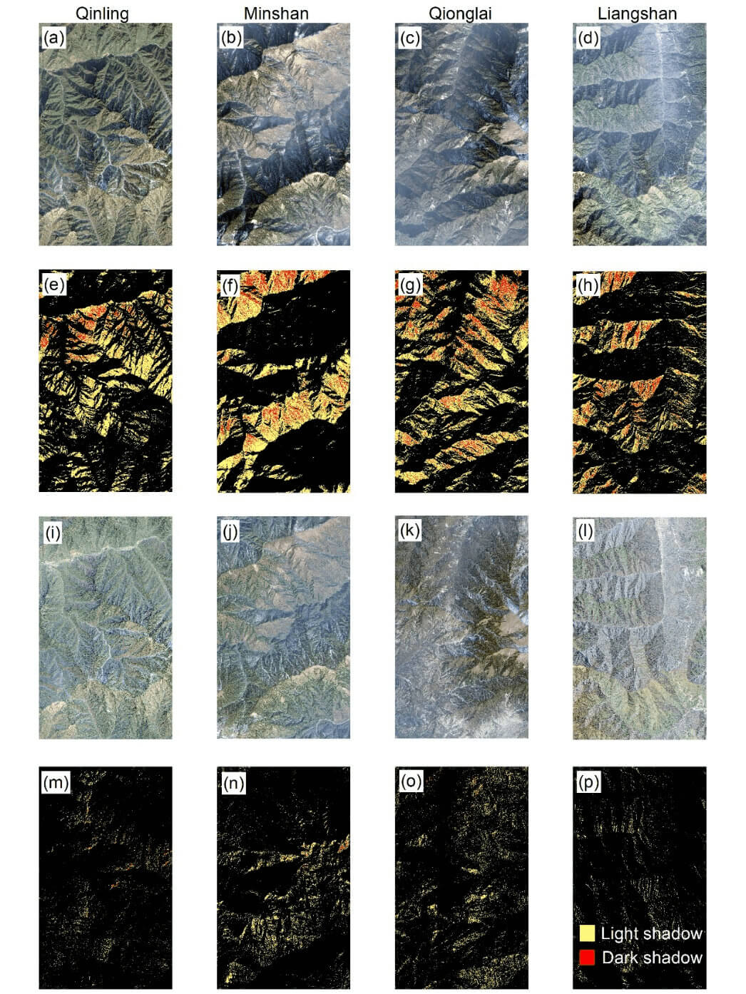
Figure 2. Satellite images of the four study sites before and after terrain shadow mitigation, along with their corresponding dark and light shadow detection results.
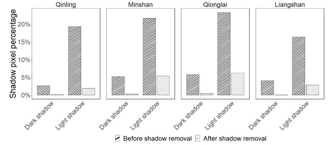
Shadows in satellite imagery can be classified as either light shadows or dark shadows, depending on the visibility of objects within shaded areas. We proposed a shadow discrimination method to distinguish light and dark shadows. Current results demonstrate that the proposed approach significantly reduces terrain shadows and enhances the detection of evergreen conifers in shaded areas. The generated maps provide valuable insights into evergreen conifer distribution within giant panda habitats.

Figure 3. Light-shadow and dark-shadow pixel percentages before and after terrain shadow mitigation at the four study sites
Key challenges included handling large-scale, high-resolution satellite datasets, addressing terrain-induced distortions, and ensuring accurate classification across diverse landscapes. Processing VHR imagery and training deep learning models required significant computational resources. The Geospatial Computing Platform played a crucial role in overcoming these challenges by enabling efficient data processing, scalable model training, and streamlined geospatial analysis. It's high-performance computing capabilities significantly reduced processing time, facilitating the generation of accurate and comprehensive forest cover maps.

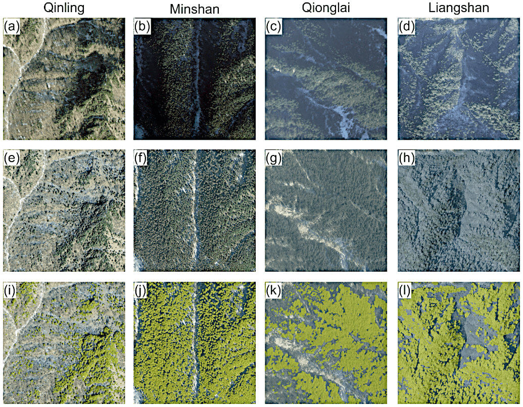
Figure 4. Examples of satellite image subsets before (a, b, c, d) and after (e, f, g, h) terrain shadow mitigation, along with evergreen conifer detection results after shadow mitigation (i, j, k, l).
Using the Geospatial Computing Platform has been a valuable experience, providing powerful tools for pre-processing and analyzing high-resolution satellite imagery efficiently. The platform’s computational capabilities enabled seamless handling of large datasets, facilitating complex geospatial analyses such as terrain shadow detection and evergreen conifer detection. It's integration of advanced algorithms and deep learning models streamlined workflows, enhancing both accuracy and efficiency. Overall, the platform proved to be a robust and reliable resource, significantly supporting research efforts in remote sensing and habitat mapping.
For more information:
Zhu, X., Wang, T., Skidmore, A. K., Lee, S. J., & Duporge, I. (2024). Mitigating terrain shadows in very high-resolution satellite imagery for accurate evergreen conifer detection using bi-temporal image fusion. International Journal of Applied Earth Observation and Geoinformation, 134, 104244. doi:10.1016/j.jag.2024.104244.

