Detecting and monitoring surface deformation using radar satellite data is vital in geohazard assessment. Sentinel-1 has provided unprecedented spatial and temporal resolution, but data processing is complicated and poses computational challenges. Although software and tools exist, each with its own limitations. SNAP-ESA is notable for its user-friendly interface and stable performance in Interferometric Synthetic Aperture Radar (InSAR). However, it lacks a flexible approach for generating interferometric time series stacks for Persistent Scatterer Interferometry (PSI) and Small Baseline Subset (SBAS) techniques and faces computational challenges over large areas.
In our study, we developed an automated Python workflow - SNAPWF - using SNAP-ESA to enable efficient PSI and SBAS interferometric time series stacks generation using flexible network graphs. SNAPWF has been implemented on the Geospatial Computing Platform of CRIB, enabling efficient performance over large areas. Results confirm its ability to generate PSI and SBAS interferometric stacks using full Sentinel-1 scenes and achieve results comparable to existing software.

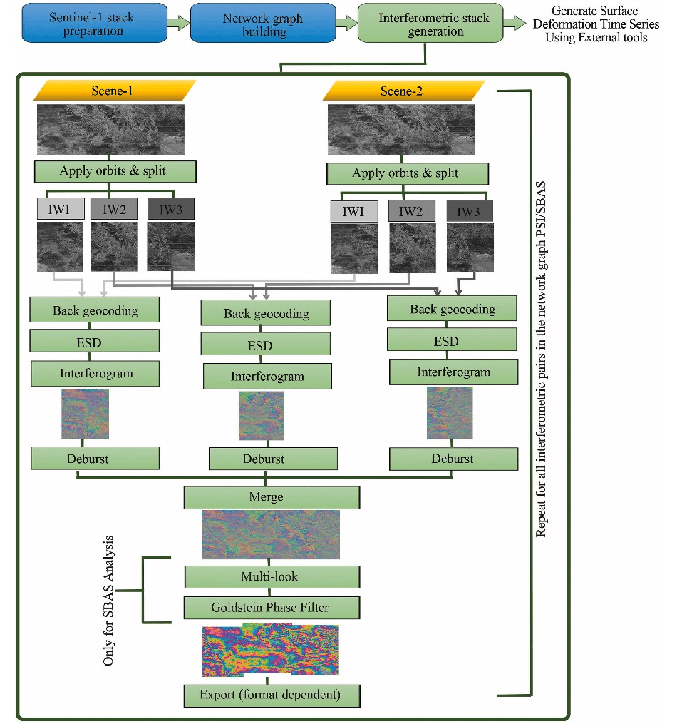
Figure 1. Schematic summary of the processing workflow divided into four main steps
The proposed workflow SNAPWF is written in Python and depends on the available open-source tools ASF-Search and SNAP-ESA, which are integrated into Python-based codes to perform the processing chain from dealing with the raw Sentinel-1 data until generating the time series interferometric stacks. The workflow introduces the flexibility of generating both PSI and SBAS interferometric stacks in which the network graphs can be easily built and modified, making it possible to generate time series interferometric stacks with different configurations. The workflow consists of four stages: 1) Sentinel-1 stack preparation and data download using ASF-Search, 2) network graph building for PSI and/or SBAS using Python, 3) Interferometric stack generation using SNAP-ESA, and 4) interferometric stack export to the desired formats for further surface deformation estimations.

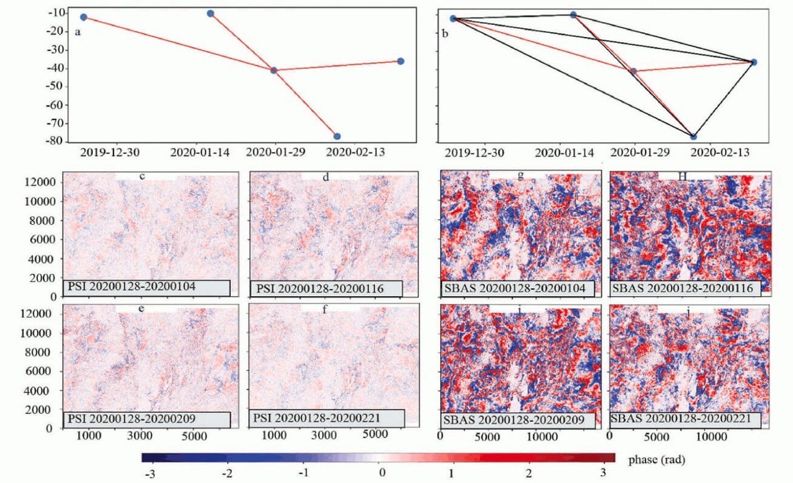
Figure 2. Examples of interferograms were generated using the PSI and SBAS graphs. (a) Shows the PSI network graph, and (b) shows the SBAS network graphs. (c, d, e, and f) show the PSI interferograms and (g, h, i, and j) show the SBAS interferograms.
In our recent publication, we describe each step and then apply the workflow to the pilot site. Moreover, we compared the generated interferograms from SNAPWF and those generated by some existing common tools such as GMTSAR, LiCSBAS and Alaska service to compare the results. The comparison results show that the proposed workflow generated interferograms of high quality similar to the ones generated by world-leading service providers and software.

Figure 3. The comparison between interferograms from a) SNAPWF, b) Alaska service, c) LiCSBAS, and d) GMTSAR for the study area.
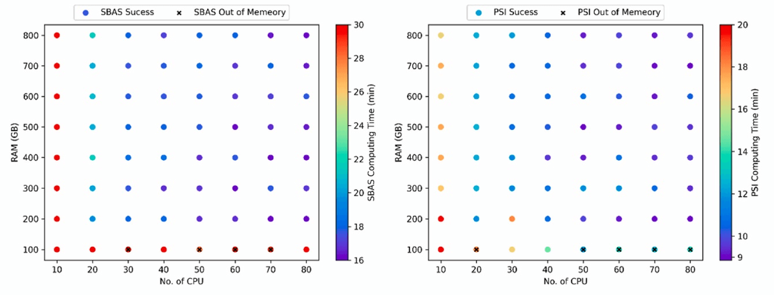
One of the main challenges was the computational requirements to process full Sentinel-1 scenes. The computational resources available at the Geospatial Computing Platform enabled us to further parallelize the workflow to significantly accelerate the processing of large volumes of SAR data. Moreover, by using the platform we tested the minimum computational requirements for future utilization of the workflow.

Figure 4. Comparison of computing times for various processing settings.
The user friendly interface of the Geospatial Computing Platform and the available flexibility of hardware, and software support were key to execute this research. The CRIB team was continuously supporting the research team, from the first moment, going through the design of the computing infrastructure required to carry out the research to the possible optimization and parallelization of the workflow, and finally, the close monitoring of the hardware and algorithms performance were all leading to the robust performance of the published workflow. Helpful discussions, advises, flexibility, and continuous support made the whole research experiences friendly and encouraging.
For more information:
Research paper:
Zaki, A., Chang, L., Manzella, I., van der Meijde, M., Girgin, S., Tanyas, H. and Faldel, I. (2023) Amira Automated Python workflow for generating Sentinel-1 PSI and SBAS interferometric stacks using SNAP on Geospatial Computing Platform, Environmental Modelling and Software, 178:106075, doi:10.1016/j.envsoft.2024.106075
Software code:
https://github.com/AmiraZakii/SNAPWF

