Greetings from the Big Geodata Newsletter!
In this issue you will find information on GeoArrow and GeoParquet for efficient analysis of large geospatial datasets, explore advancements in Zarr Python 3.0 for scalable data storage, uncover insights on IBM's Geospatial TensorLakehouse for enhancing geospatial AI analysis, and learn about cutting-edge solutions like NVIDIA Earth-2 for solar irradiance prediction and the hybrid quantum-classical convolutional neural network (QC-CNN) for EO data.
Happy reading!
You can access the previous issues of the newsletter on our web portal. If you find the newsletter useful, please share the subscription link below with your network.
GeoArrow and GeoParquet: Transforming Geospatial Data Analysis
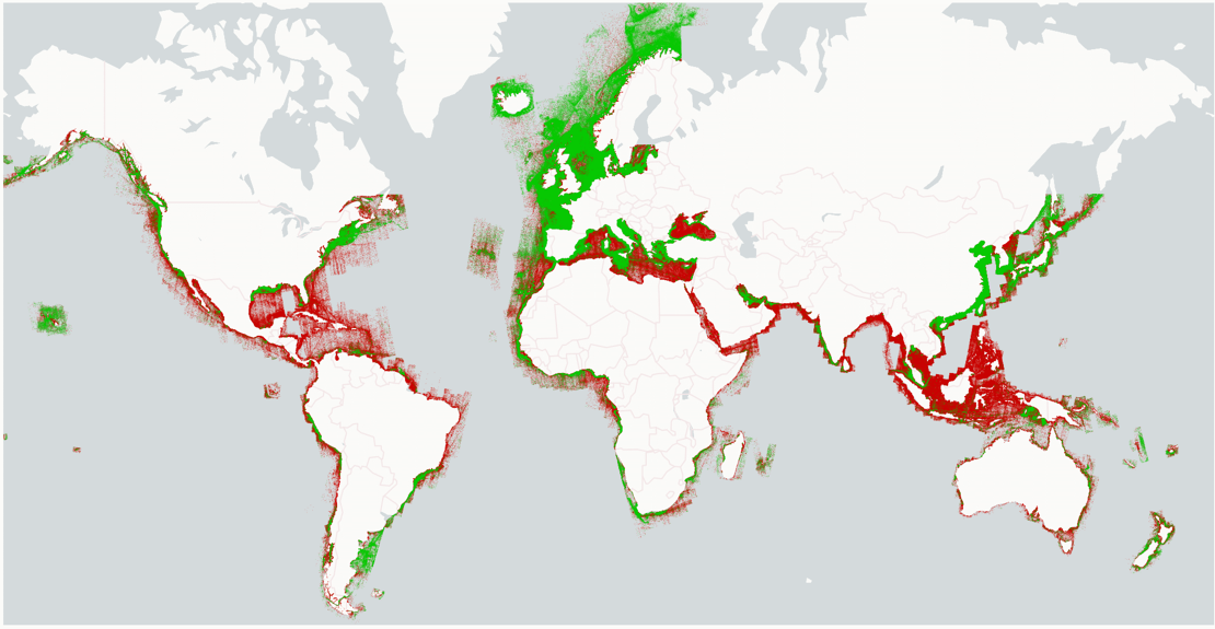
Image credits: Wherobots, 2024
Kyle Barron discusses the innovations behind GeoArrow and GeoParquet in a recent interview, highlighting their potential to reshape geospatial data analysis. These open-source standards aim to make geospatial data more accessible, performant, and interoperable across diverse tools and workflows. GeoArrow is designed to store vector geometries efficiently using Apache Arrow's columnar memory format. This structure supports faster in-memory computation, reducing overhead during data processing. Meanwhile, GeoParquet extends Apache Parquet, enabling on-disk storage of geospatial data with schema definitions for geometries, making it compatible with modern analytics platforms. Barron emphasizes that these technologies eliminate format-specific barriers for smoother integration with cloud-native workflows. As geospatial datasets grow in complexity and size, tools like GeoArrow and GeoParquet are crucial for efficient, scalable, and accessible data analysis. They represent a step toward a unified, open-source ecosystem for big geodata management.
Read the full interview with Kyle Barron to explore the details of GeoArrow and GeoParquet here. Learn more about cloud-native geospatial tools here.
Zarr Python 3.0: Advancements in Scalable Data Storage
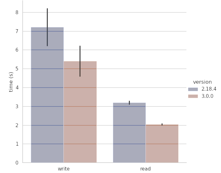
Image credits: Earthmover, 2024
The release of Zarr Python 3.0 introduces several updates that enhance its capabilities for managing large, multidimensional datasets. Designed for scientific and geospatial applications, Zarr offers a flexible framework for scalable data storage and access. Version 3.0 includes multi-scale support, allowing datasets to be stored and analyzed at varying resolutions, which is crucial for geospatial and scientific workflows. It also features improved compatibility with cloud storage platforms like AWS S3 and Google Cloud Storage, ensuring efficient access in distributed environments. A notable addition is support for the chunk-sharding extension, which optimizes storage and retrieval by enabling smaller chunks to be grouped into shards, improving performance in cloud-native storage systems. With chunk-sharding, the number of stored objects is decoupled from the chunk size. Users can safely create very large Zarr arrays with very small chunks without generating a glut of stored objects. Enhanced metadata management further strengthens interoperability with tools like Dask and Xarray. Supported by the Pangeo Project and a collaborative open-source community, Zarr Python 3.0 aims to simplify workflows for researchers and data scientists working with complex datasets.
Learn more about the Zarr Python 3.0 release and its features here. Discover how Zarr supports large-scale data storage and analysis here.
IBM's Geospatial TensorLakehouse: Enhancing Geospatial AI Analysis
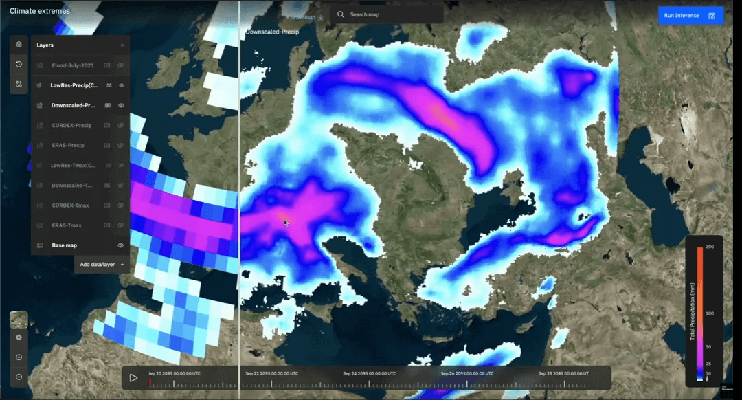
Image credits: IBM Research Blog, 2024
IBM’s Geospatial TensorLakehouse provides a practical solution for geospatial data integration, storage, and analysis. Combining a data lakehouse architecture with TensorFlow-based geospatial AI tools, it simplifies the management of complex datasets and supports efficient geospatial workflows. The TensorLakehouse supports various data types, including raster and vector formats, and is optimized for cloud-native environments. It integrates seamlessly with popular AI frameworks such as TensorFlow and PyTorch, and by unifying data representation it reduces preprocessing time and improves workflow efficiency. IBM demonstrated the capabilities of TensorLakehouse at the AGU 2024 Fall Meeting, highlighting its application in geospatial AI research. The platform focuses on improving interoperability and scalability, making it a valuable resource for researchers and organizations working with geospatial data.
Learn more about IBM’s Geospatial TensorLakehouse here. Explore its features and recent presentation at AGU 2024 here.
Advancing Solar Irradiance Prediction with NVIDIA Earth-2

Image credits: NVIDIA Developer Blog, 2024
NVIDIA Earth-2 leverages advanced AI to enhance solar irradiance prediction, a critical factor for optimizing solar energy systems. By integrating Earth system models with NVIDIA's Omniverse and AI-accelerated simulations, Earth-2 offers high-resolution insights into solar radiation patterns, cloud dynamics, and atmospheric conditions. The platform utilizes the FourCastNet model, a neural network trained on global weather data, to predict solar irradiance more efficiently than traditional methods. This approach reduces computational costs while improving prediction accuracy for both short-term and long-term forecasting. NVIDIA's use of physics-informed neural networks (PINNs) ensures that the predictions adhere to established physical laws, delivering reliable and actionable insights. Earth-2's capabilities extend beyond energy optimization, contributing to climate resilience by providing critical data for renewable energy deployment and grid management.
Learn more about NVIDIA Earth-2 and its applications in renewable energy here. Explore NVIDIA's contributions to climate-focused AI innovations here.
Upcoming Meetings
- Good Practices in Research Software Development
eScience Centre, Online, 3 - 6 February - AWS Training on Cloud-based Geospatial Computing
ITC, Enschede, 4 February - Introduction to Supercomputing, part I
SURF, Online, 4 February - High Performance Machine Learning
SURF, Amsterdam Science Park, 5 February - The Carpentries Instructor Training
eScience Center, Amsterdam, 4 - 5 March - Introduction to Geospatial Raster and Vector Data with Python
ITC, Enschede, 12 - 13 March - Cloud Native Geospatial Conference 2025
CGN, Utah, USA, 30 April - 2 May
The "Big" Picture
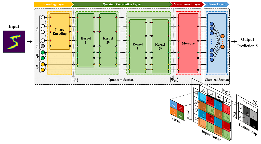
Image credits: Modified from Fan et al., 2024
A recently proposed hybrid quantum-classical convolutional neural network (QC-CNN) introduces a novel approach for classifying remote sensing images into multiple categories. This model leverages quantum computing to accelerate feature extraction, achieving better performance than its classical CNN counterpart. By employing amplitude encoding, the QC-CNN significantly reduces the quantum bit resources required, making it more feasible for current quantum systems. The study evaluates the QC-CNN on EO benchmarks such as Overhead-MNIST, So2Sat LCZ42, PatternNet, RSI-CB256, and NaSC-TG2. Experimental results demonstrate its effectiveness, highlighting its potential to outperform classical models while offering higher generalizability. The impacts of quantum gates, measurement strategies, model structures, and noise effects on classification performance were also analyzed, offering valuable insights into the behaviour and capabilities of quantum models. Due to its computational efficiency and low qubit requirements, the QC-CNN shows promise for addressing challenges in the remote sensing domain, especially as quantum hardware advances. Future research directions include exploring new image encoding techniques, studying the role of quantum gates and measurements, and addressing challenges such as incomplete or noisy labelled data in EO tasks.
Explore the hybrid QC-CNN model in detail here. Find out more about quantum computing here.
Fan, F., Shi, Y., Guggemos, T., and Zhu, X. X. (2024). Hybrid Quantum-Classical Convolutional Neural Network Model for Image Classification. IEEE Transactions on Neural Networks and Learning Systems, 35(12), 18145–18159. doi:10.1109/TNNLS.2023.3312170.